By J.E. Kennedy

In Fredericton, New Brunswick, on the campus of the University, stands a stone pillar, a stalwart memorial to the contributions of Dr. William Brydone Jack in the field of practical surveying. This landmark is situated on the true meridian line at a distance of 8.82 chains due South of the transit room of the Observatory. It has not been used in scientific observations for the past twenty-five years.
The interest of a member of the University Senate has prevented it from falling into complete obscurity. A record book of observations made at this stone pillar was uncovered about five years ago and presented to the Archives of the Library by Dr. C McN. Steeves. Through his efforts, the pillar has since been protected by an enclosure, and a copy of Dr. Jack’s report to the Surveyor General placed on display at the site.
In 1840, Dr. William Brydone Jack was appointed to King’s College, Fredericton, as Professor of Mathematics, Natural Philosophy and Astronomy. It is logical to find that his interest in the practical aspects of these subjects should prompt him to introduce a course on surveying in the college curriculum. It is noteworthy that the introduction of such a practical subject should make a large contribution to the very survival of King’s College.
The foresight of Dr. Jack in realizing the need for training students in engineering, together with the support he received from the Governor of New Brunswick, Sir Edmund Head, were responsible for King’s being one of the first institutions in British North America to initiate, in 1854, a course in engineering instruction. In achieving this end, Dr. Jack had met with bitter opposition internally from the classically trained and highly cultured President, Dr. Jacob. But in the period, 1855-1860, the existence of this course of practical training for the young men of the Province enabled the College to withstand successfully the violent attacks made upon it by the members of the Legislative Assembly of New Brunswick.
Two decades later, when Dr. Jack was President of the University of New Brunswick, the records reveal that his interest in practical surveying had continued. The 14th Annual Report of the Crown Land Department of the Province of New Brunswick for the year ending October 31st, 1874, concluded with the following:

On April 8th, 1874, an Act had been passed (37° Victoriae, A. D. 1874, Cap. XXI) pertaining to Land Surveyors and the Survey of Land in the Province of New Brunswick. A few sections of this Act are quoted below.
(1) Board of Examiners appointed:
There shall be a Board of Examiners for the examination of candidates for admission to practice as Land Surveyors in the Province of New Brunswick, and such Board shall consist of the Surveyor General, and such other competent persons not exceeding three, as shall be appointed from time to time by the Lieutenant Governor in Council.(4) Qualifications of Candidates for Surveyor:
Before any person is admitted to practice as Land Surveyor in this Province he shall be examined by the Board of Examiners as to his competency and the sufficiency of his instruments: The Board shall test him as to his knowledge of the following subjects—Arithmetic, Algebra, Geometry, Mensuration, Trigonometry and the use of Logarithms, Surveying and Dividing Lands, Plotting and Map Drawing, and Spherical Trigonometry and Astronomy so far as will enable him to lay down a true meridian line and ascertain the latitude; he shall also be required to submit his instruments for the approval of the Examiners, and perform such practical operations in their presence as they may require, both in regard to the use of the instruments and their adjustments;…(8) For Testing Instruments a true meridian line &c. to be laid down:
For the purpose of testing and verifying Surveyors’ Instruments there shall be laid down and properly marked, on suitable ground at Fredericton, the exact length of a standard chain, and the direction of the true meridian;…(9) Instruments now in use to be tested within one year:
For the sake of ensuring greater uniformity in the instruments used, and the work done by different Surveyors, every Surveyor now practicing in the Province shall, within one year from the passing of this Act, bring or send to Fredericton his instruments, for the purpose of having them tested and verified by the Board of Examiners; and the Board shall have power to condemn and forbid the use of all instruments which they may find defective or incapable of giving accurate results;…
The first meeting of the Board was held on January 11th, 1875. The Surveyor General was made Chairman and W. P. Flewelling was appointed Secretary. A report to the Surveyor General, dated October 17th, 1874, was then presented by Dr. Jack.
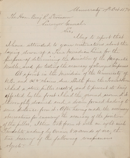
Sir:
I beg to report that I have attended to your instructions about the laying down of a True Meridian Line for the purpose of determining the variation of the Magnetic Needle, and for testing the accuracy of Surveyors’ Compasses.
At a point in the Meridian of the University of New Brunswick and 8.82 chains due South from the Transit Room I had a stone pillar erected, and to prevent its being affected by the frost I had the ground around it thoroughly drained and a drain formed leading to some distance from it.

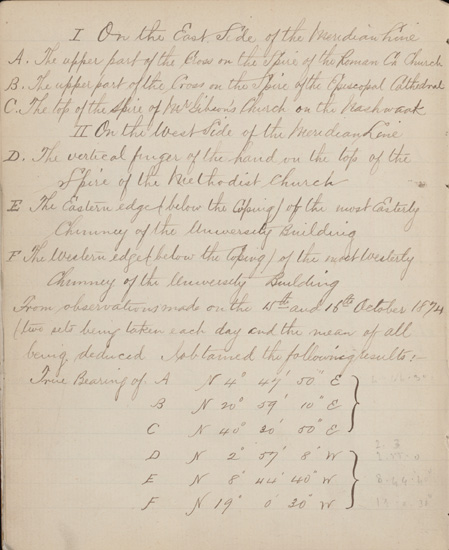
Once Dr. Jack had taken observations for ensuring the accuracy of the position of the pillar, true bearings of six conspicuous objects were made with a theodolite, three on the east side and three on the west side of the meridian line from which he determined the magnetic variation at Fredericton.
I. On the East Side of the Meridian Line
A. The upper part of the cross on the spire of the Roman Catholic Church.
B. The upper part of the cross on the spire of the Episcopal Cathedral.
C. The top of the spire of Mr. Gibson’s Church on the Nashwaak.II. On the West Side of the Meridian Line
D. The vertical finger of the hand on the top of the spire of the Methodist Church.
E. The Eastern Edge (below the coping) of the most Easterly chimney of the University Building.
F. The Western edge (below the coping) of the most Westerly chimney of the University Building.
Of the four church spires mentioned, only D remains today as it was in 1874. This is the famous spire on the Wilmot United Church, sometimes called the “Church of the Index Finger”. A large hand, with the index finger pointing upwards, terminates the top of the steeple.
In 1876, through the efforts of Dr. Jack an additional storey was added to the University Building and the chimneys were raised to a new elevation, but not changed in bearing with reference to the true meridian line. Over a period of years, trees gradually began to obscure the conspicuous objects from view, and in 1892, another point G was added, the top of the lightning conductor of the Parliament Building. The “new” Buff and Berger Theodolite, with which the bearing of this object was taken is still used by students in surveying at the University today.
A Committee consisting of Dr. Jack and Edward Jack was appointed by the Board at its first meeting, and instructed to lay down the exact length of a standard chain in the Hall of the University. By June 1875, this work had been completed and was reported on by Dr. Jack. A recent search of the most probable floor areas in the Arts Building has not revealed the location of this reference standard.
The Act defined, in Section (4), the qualifications required of candidates for Surveyor. The first meeting of the Board ended with an examination of presumably their first applicant. The candidate “was examined orally and by written questions (the questions proposed being of the simplest nature) but he failed to give satisfaction. Moreover, he professed no knowledge of Algebra, and also has no instruments. The Board therefore resolved that he could not receive a Commission”.
An example of the neat records made and copied by Dr. Jack is shown below.
On March 10th, 1875, a certain Mr. Buttimer brought two identical circumferentors for testing. In the record book, Dr. Jack distinguished these instruments by referring to them as “Buttimer” and “McManus”. The derivation of “McManus” is herewith suggested.

Dr. Jack was born and educated in Scotland and carried his native tongue to his adopted country. In his lectures in Mathematics the symbols of plus and minus were always pronounced as plus and manus. To the students, he became fondly known as “Manus Jack”. His good humour and entertaining nature were at their best when the “McManus” instrument was being tested.
The implementing of Section (9) of the Act was the chief reason that so large a number of instruments (compasses, circumferentors and chains) were submitted for testing in the years 1875 and 1876. The record book contains some very shrewd comments on the ability of some of the Deputy Land Surveyors in handling their equipment, and on whether the instruments should be passed or rejected for service.
Astronomical work was to Dr. Jack a labour of love and the testing of surveyors’ instruments was no more lucrative. A summary of his work completed between February 18th, 1875, and August 9th, 1876, was found in a memo attached to the Record book of the Board of Examiners. A total of forty-two instruments were examined in this interval. On the outside of the memo is a warrant to issue Dr. Jack a sum of $25.00 to cover his efforts.
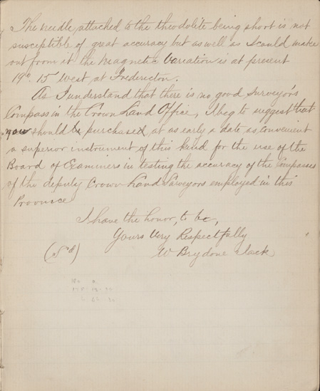
A plot of the magnetic data for Fredericton (Herbert, 1926) gives the value of the magnetic variation for the year 1870 as 19° 38´ W., for 1880 as 19° 54´ W., with an annual change of 1.6´ W. In the period, 1874-76, the variation was from 19° 45´ W. to 19° 48´W. In 1874 Dr. Jack reported 19° 15´ W., which is not in good agreement with the above, but in 1875, the average given by the tests of the various instruments was 19° 52.6´ W.
“The needle attached to the theodolite being short is not susceptible of great accuracy”. Hence, this original discrepancy becomes quite understandable. In his initial report, and on a number of other occasions, Dr. Jack urged the Surveyor General to purchase a “superior instrument” to be used as a standard of reference in testing surveyors’ compasses. There is no record that his suggestion materialized.
Magnetic observations for Canada, and the transfer of these data to magnetic maps, are now made by the staff of the Division of Geomagnetism of the Dominion Observatory, Ottawa, headed by Mr. R. G. Madill. Their records show that observations were taken at this stone pillar as recently as the years 1925, 1927 and 1929. There may well be “repeat” magnetic measurements made at this pillar in the years to come.
The twentieth century belongs to Canada. The increased industrial growth of this nation is forcing us to search for additional sources of minerals and raw materials. New areas must be surveyed and developed each year by trained engineers from this and other Canadian Universities. It is well to pause and recognize the debt we owe to pioneers like Dr. Jack in this field of practical surveying. Their foresight and action during the past century are making it possible for us to meet the present challenge.
References
- 37° Victoriae, A. D. 1874, Cap. XXI, Acts of the General Assembly of Her Majesty’s Province of New Brunswick.
- Herbert, W. H., 1926, Bulletin 58, The March of the Compass in Canada.
- Records of the Board of Examiners for the examination of Candidates for admission as Land Surveyors, Crown Land Office, Fredericton, N.B.
- Report of Dr. William Brydone Jack to the Surveyor General, dated 17th October, 1874, U.N.B. Archives.